|
Today we passed the second part on the Karakoram highway to Skardu, the last town on our way. We had to master several hindrances...
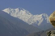
We could not take all of our luggage from Islamabad yesterday, because there was not enough space in our bus. It should be transported by another car that should meet us in Chilas. However, it did not arrived this morning, yet. So we hoped it will arrive in Skardu and started at 5.40 a.m. from Chilas. On the first kilometers, we already viewed som highlights. E.g., the Rakhiot site of the Nanga Parbat, which towers above the Karakorum Highway by more than 7000 (!) meters.
Some kilometers later, the confluence of the Indus with the river Hunza marks one of the most important geographic points of Asia. At this spot, the three highest mountain ranges on Earth meet each other: Himalaya (max. elevation: 8850m, Mount Everest), Karakorum (max. elevation: 8611m, K2) and Hindukush (max. elevation: knapp 7690m, Tirich Mir) . This spot, called "Junction Point", is something like a place of pilgrimage for geographs.
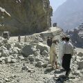
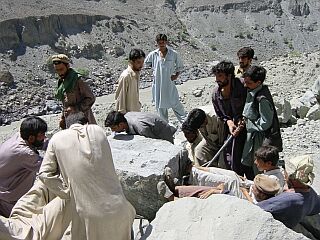
Little later, we left the Karakorum Highway and follow the river Indus through giant gorges toward Skardu. The road is even smaller and more spectacular than the KKH and rock falls occur more often. And one of these rockfalls we see shortly later. Luckily, the road has been already closed and workers do controlled rock falls 50m above the road. Thereafter, the road remains closed for 2 hours and the rocks are removed with simple technical aids. Finally, we arrive at Skardu, where the rest of our equipment also arrives in the evening.
Tomorrow, we will do last shopping and distribute our equipment for the carrymen with 25kg each and continue our way by Jeep to Askole.
Markus Walter
|